To
integrate with their History unit on Egipto
(Egypt), el segundo (2º) grado has been learning some Spanish vocabulary related to this study. We
began by viewing a PowerPoint that introduced us to the geography of Egipto. To understand the country’s coordinates on a mapa (map), we first learned about the brújula (compass) and the puntos cardinales (cardinal points):
norte
– north
sur-
south
este
– east
oeste
– west
noreste
– northeast
sureste
- southeast
noroeste
– northwest
suroeste
- southwest
Afterwards,
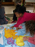
using a large floor mapa, the
students were invited to locate and determine the whereabouts of Egipto and its neighbors. Upon asking, ¿Dónde está….? (Where is…?) , the
students were able to respond as follows…
Egipto
está noreste de África. – Egypt
is northeast of Africa.
Sudán
está sur de Egipto. – Sudan is
south of Egypt.
Libia
está oeste de Egipto. – Libya is
west of Egypt.
Arabia
Saudí está al este de Egipto. – Saudi Arabia is east of Egypt
El
mar Mediterráneo está al norte de Egipto. – The Mediterranean Sea is north of Egypt.
El
mar Rojo está al este de Egipto. – The Red Sea is east of Egypt.
The
second graders were having so much fun determining the location of Egipto’s neighbors that they asked for
more opportunities to find other countries. So, to challenge them, each was
asked to find a given country’s name…in Spanish!
¿Dónde está Inglaterra
(England)?
¿Dónde está Japón (Japan)?
¿Dónde está Turquía
(Turkey)?
We
also learned how to read latitud
(latitude) and longitud (longitude)
on el mapa. The students were
provided with activities to showcase their knowledge and they were truly
remarkable!
Next, we will be learning vocabulary for artifacts and places
pertaining to ancient Egypt. Stay tuned!


No comments:
Post a Comment